Stirling Village: redevelopment without destruction
Imagine a redevelopment project that could bring 50 new apartment units and 20 new retail shops, offices, and restaurants into a neighbourhood. It doesn't sound terribly ambitious, but it could make a welcome addition to many semi-urban residential areas.
Now, imagine you could accomplish this without tearing down a single house, without displacing a single person who already lives there. Imagine the new buildings would be 2 or 3 stories at most, blending nicely into the existing strip of single-detached houses.
And what if this redevelopment project could happen largely on publicly-owned land? No, I'm not talking about developing on top of parkland or any public space that is used and valued by the current residents.
I'm talking about putting new buildings smack-dab in the middle of a four-lane roadway.
Bear with me here.
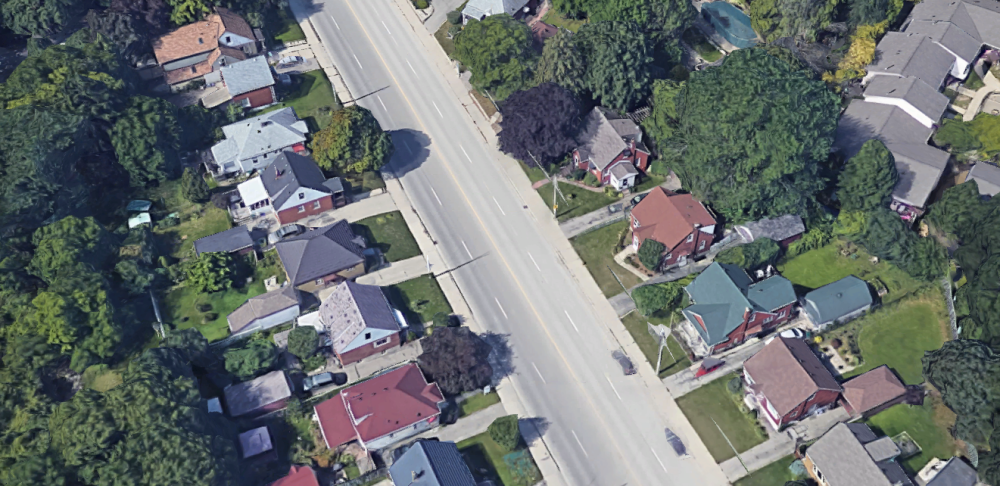
The project area: Stirling Avenue
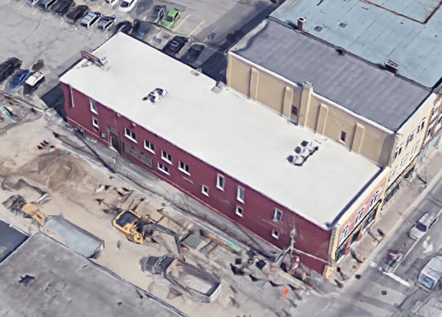
(figure: current.jpg)
This is a section of Stirling Avenue South, near downtown Kitchener. Cameron Heights high school is to the North -- it contains a public swimming pool, excellent tennis courts, a football and soccer pitch, and a 400-metre track. This is most definitely a community hub for recreation.
South of Stirling, you'll notice the Iron Horse Trail, a major cycling route. It's important infrastructure for commuters, dog-walkers, and neighbours who like to go out for a Sunday stroll.
The triangle-shaped building to the right of this image is 50 Kent, the local headquarters for Mennonite Central Committee. It's also my closest Credit Union branch, and contains a nice thrift store.
In the top-right corner of this satellite photo, you can see the ION light rail tracks being built along Charles Street. Opening within the next year, the closest train stop will be just a few minutes' walk away.
Finally, notice that the properties lining Stirling Avenue are largely single-detached houses. There's the recreation grounds, of course, and a Synagogue towards the bottom-left.
I point all this out because I want to emphasise that this neighbourhood is already quite vibrant. It has a mix of uses and community hubs. I'm sure there are a lot of proud, longtime residents here. And I wouldn't ever want to wipe this slate clean for a high-minded redevelopment project.
That said, there is one major barrier here: Stirling Avenue is a four-lane traffic sewer where motorists drive far too quickly, and this breaks up the neighbourhood. There are no pedestrian crossings between Courtland Avenue and Charles Street, a distance of about half a kilometre.
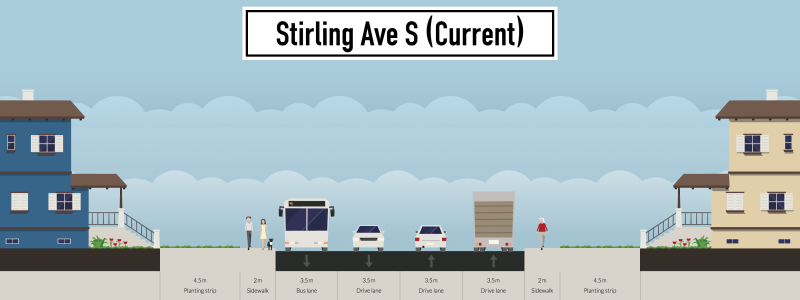
This is what a cross-section of Stirling Avenue looks like today:
And here's what I imagine it could become. I call this concept Stirling Village:
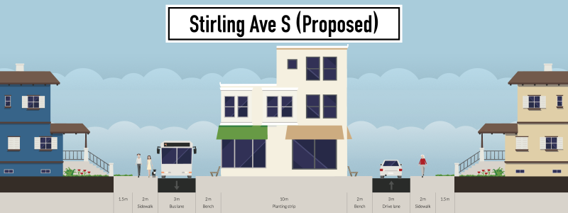
A vision of Stirling Village
Hypothetical street-section diagrams are fun to create, but what kind of building can you actually squeeze into 10 metres? As it happens, we have lots of examples in Kitchener-Waterloo we could turn to.
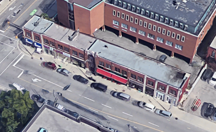
The Duke Food Block is only 6 metres deep, and 52 metres long. It houses 4 restaurants, a convenience store, a shoe-repair business, and 7 apartment units on the upper floor.
The Working Centre's building at 66 Queen Street South is 12 metres by 41 metres. It contains Maurita's Kitchen, a computer recycling and repair centre, along with some office space and apartments.
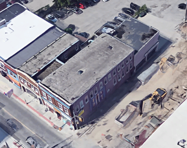
Full Circle foods is another building that's only 10 metres deep. Together with its adjacent neighbour, home of The Games Exchange, this building measures 10 metres by 36 metres.
All of which to say, there are lots of buildings already in Downtown Kitchener that fit into the 10-metre envelope. And look at the diversity of uses they bring!
How would these kinds of buildings fit into the existing street to make Stirling Village work? Let my mediocre Photoshop skills paint a picture for you:
If you look closely, you'll see a new set of sidewalks up against the new buildings, which leaves one lane of traffic on either side. You'll also notice the existing front lawns have been reduced to 1.5 metres.
The case for traffic calming
Regardless of a redevelopment proposal, this stretch of Stirling Avenue is ripe for traffic calming in its own right. Less adventurous places than this blog might propose a road diet to bring Stirling down to two lanes, and create cycling paths and wider sidewalks.
For users of the Iron Horse Trail, the crossing at Stirling and Courtland is an awkward encounter -- a jarring discontinuity of the trail where people have to navigate a tricky high-speed intersection.
Cars leaving downtown start to speed up significantly between Charles and Courtland. It's uncomfortable to walk or bike here.
At the same time, Stirling is not a vital arterial road for cross-city traffic. One block east of this project area, Stirling narrows significantly at King Street as it enters a quiet residential area. It's listed as a "Major Community Collector Street" in Kitchener's Official Plan, which is two steps lower than the "Regional Road" designation which four-lane roads typically fall under.
Stirling Village is very close to King Street, and more people will start walking along this route to get to and from the ION light rail stations when it opens. Adding an intersection with traffic lights at the midpoint of this block would also help connect the walking and cycling routes from the Iron Horse Trail to Cameron Heights.
Public support
Asking residents to give up 3 metres of their front lawn -- and probably one of the parking spaces in their driveway, too -- might be a tall order. But at the same time, Stirling Village would replace a loud, busy, dangerous stretch of 4-lane road with a traffic-calmed, one-lane street. This tradeoff might just be enough to drum up some YIMBY support from the residents.
(Do you live along this stretch of Stirling? If so, absolutely leave your thoughts in the comments. I'd love to hear how off-base I am.)
Public money
The last issue I'll raise is that of money. Since the city owns the roadway to begin with, it is creating a brand-new tax base out of thin air. They'll also be able to sell the 5 or 6 properties to bring in more revenue. The great thing about selling public land is that other public agencies get first dibs (like the Region's affordable housing program).
The cost of rebuilding the road, moving utility lines, and purchasing bits of peoples' front lawns would be more than paid for by selling off the new blocks for development, and collecting property taxes from them over time.
Can this work in other neighbourhoods?
So, can this concept be applied elsewhere? I think so. Find a wide, four-lane road that seems overbuilt for its neighbourhood. Even better if it's flanked by low-density houses with large front lawns.
Even with generous road widths, it's quite the squeeze to insert a whole new block of buildings. To make it work here, I've had to assume zero-lot-line development, bare-minimum sidewalks and road lanes, and clustered parking arrangements.
Would you like to see Stirling Village happen? Where else do you think this could work? Send me your ideas!
Sam Nabi